| 3D modeling as a tool for archaeological exploration |
| Using images or videos taken from manned aircraft and/or drones |
| Updated draft, May 6, 2018 |
NEW: explorations using images from drones in Ica, including Nazca, in progress. See Section VII.
I. Introduction
In the world of Archaeology there are
several recent reports of discoveries that are being
realized through the examination of remote imagery of different
types. Here we only give a few examples of this:
(a) An
ancient buried
village was found using a drone in New Mexico, USA.
(b)
"Improving
archaeological prospection using localized UAVs assisted
photogrammetry: An example from the Roman Gold District of the Eria
River Valley (NW Spain)".
(c)
Sarah Parcak: "Technology of the future is helping us save our
past".
(d) Last is best:
Lost Maya Megalopolis in Guatemala found using LIDAR technology
(NatGeo, Feb.1,2018).
Aside from helping to discover archaeological sites,
visualization and analysis of 3D models has for many decades been
used in geological exploration and also aided in the discovery of spectacular
natural landmarks. As a vintage example of the latter, the largest "natural
bridge" in the world, was discovered in 1961 by using a
stereoscope for 3D viewing aerial photographs taken by Peru's National
Air Photography Service.
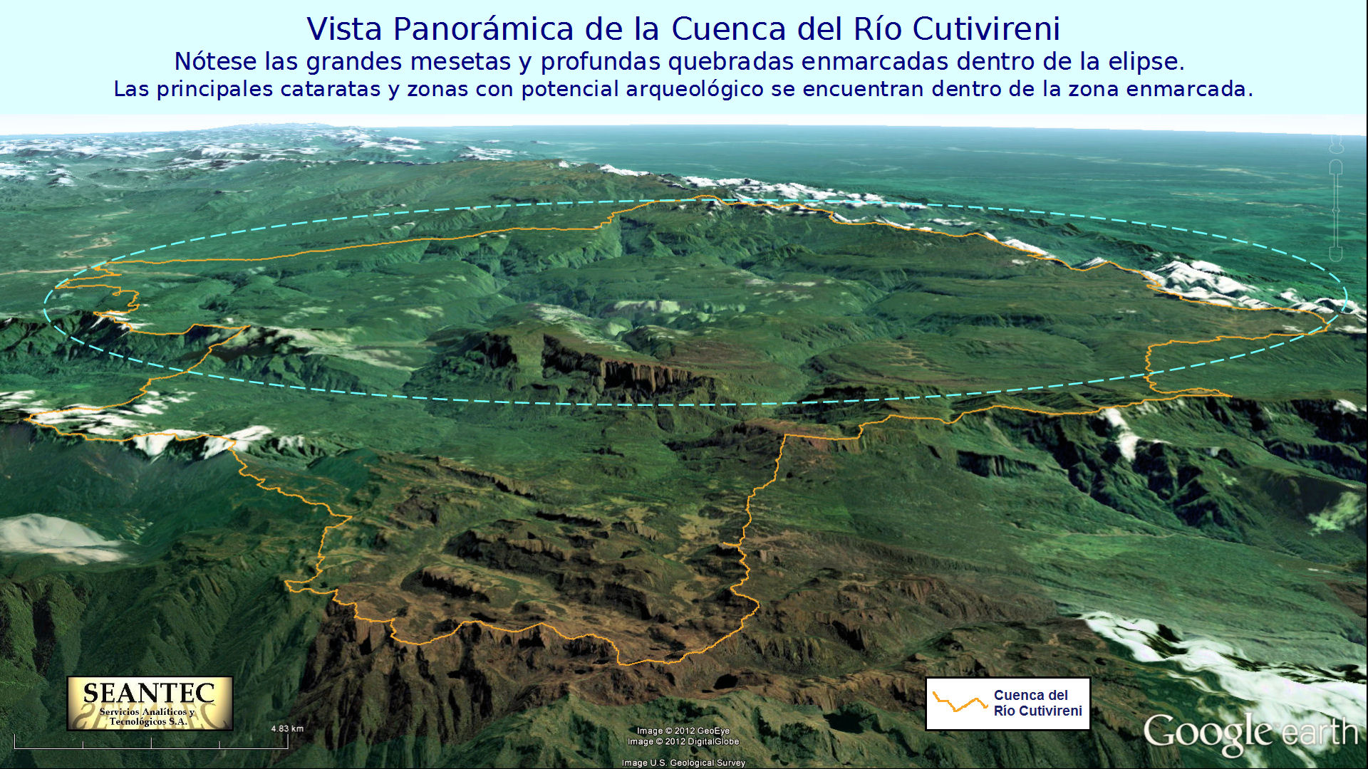
In America there
are thousands of known ancient indigenous ruins in various states of
preservation, and according to mainstream archaeology in Peru they cover various periods
from around 5000 years ago (Caral),
to the time of the Spanish Conquest between 1521 and 1535 or even
later. Some of the best preserved archaeological sites are in the
Cusco region, of which Machupicchu, located in the mountainous
rainforest northwest of Cusco, is well known worldwide. The main reason
for the good preservation of the famous Cusco sites is the superb
craftsmanship of the buildings, whose masonry techniques remain a
mystery as those of the
Puma Punku site in Bolivia.
In Perú
there are many legends about "lost cities of
the Incas" in regions to the northwest (Vilcabamba)
and east of Cusco (Paititi)
which have not been unequivocally found to date in part due to the
dense forest that has covered many possible structures dispersed in
thousands of square kilometers that have not been sufficiently
explored. In addition we have increasing evidence that there is a
hidden population living in the plateaus of the northern
Vilcabamba mountains, perhaps the descendants of the Incas
themselves, which could be the peruvian counterpart of an until
recently unknown
indigenous
civilization found only a few decades ago in the rainforest of
the
Sierra Nevada de Santa Marta. A very
interesting
conference was given in June 2014 at the Google Outreach offices
in California with two of the leaders of one of the four ethnical
groups living in the Sierra Nevada. This almost hour long conference
includes presentations by different experts of which the brilliant
geographical description by the chief cartographer of the Amazon
Conservation Team (ACT) is especially noteworthy (minutes 8:52 to
22:55).
With modern technological tools it is now
possible by air to effectively discover hidden structures (Images
1 and 2), and measure them with
sufficient accuracy using 3D Photogrammetry, for
determining whether these structures are natural or man-made, all of
this before venturing into the much more expensive verification on
land. In other words, investment in exploration can easily be
justified due to the low cost of the new methods and the speed of
its realization.
The remainder of this essay partially
recounts an aerial exploration experience of 2012 in the middle
of a dense mountainous jungle in Peru, includes an example of 3D
reconstruction and measurements using
Pix4Dmapper Pro with images obtained from a video clip in that
flight, analyzes a few of the anomalies detected therein, makes some
recommendations for future exploratory strategies, and in the
Appendix presents a few interesting anaglyph images which require
special glasses for visualization.
II.
Obtaining the Data
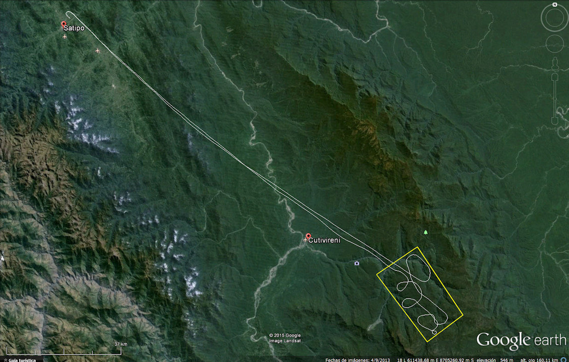
In July 2012, a
Cessna U206G single-engine plane piloted by Enrique Tantte took off
from a small airstrip in
Satipo
for a scouting mission looking for hidden archaeological remains in
the highlands of the
Cutivireni river basin. Antonio Gómez, Jorge
Gómez (†), Jorge Mattos and a representative of the
Otishi
National Park headquarters in Satipo contributed in this
expedition with photos and videos. The Cutivireni river is the main
tributary of the
Ene
river. The objective was to take still images and videos of an
area of around 400 square kilometers on plateaus with altitudes
between 2200 and 2600 meters above sea level that had been partially
explored in previous aerial missions, having found a lot of traces
of ancient human activity in the region but nothing conclusive
relating to an important "lost city".
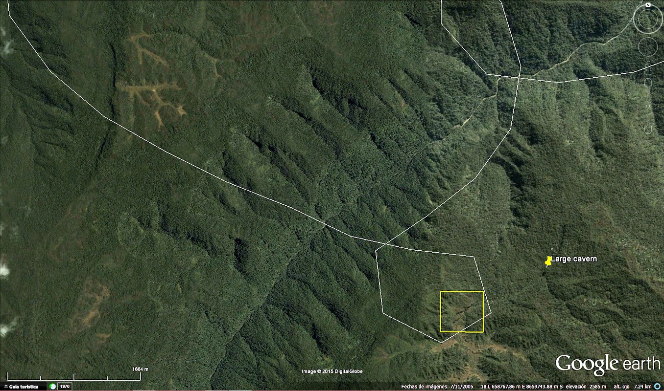
Image
3 shows a Google
Earth map with the flight path registered by a Garmin GPS, and a
yellow rectangle showing the planned area of interest. At that time
we did not have any knowledge of the new 3D reconstruction methods
so the flight was not optimized for this type of image processing.
Two spectacular anomalies were
accidentally discovered in this flight. Image 4 and
Image 5 by
photographer Antonio Gómez show these features. You can click on
each image for a larger view.
|
|
|
|
| Image 4: Two views of
a large tower discovered in July 2012. Its height can be approximately estimated in 30 meters. n |
Image 5: Large cavern entrance discovered
in July 2012. The width is estimated at approximately 34 meters. n |


Unfortunately
insufficient images were taken of these features in the number and
manner that would make it possible to realize a 3D photogrammetric
reconstruction from them. However some pairs of images enabled us to
create stereo-anaglyph images of the objects in images 4 and 5. In
the Appendix of this essay we show these anaglyphs and those of other interesting features in the
region.
Fortunately, upon examination of the flight
path and the videos of the expedition, we found an interesting feature
within a small loop in the southernmost part of the flight where a
Full
HD video was taken by Jorge Gómez in a favourable trajectory and angle
for obtaining a 3D model. Image 6 is a Google Earth
image of the area selected for the 3D model, part of the GPS track and the surrounding
general area showing a few of the hundreds of traces of possible
ancestral intervention by human beings of the Megalithic Age in the
region. Extracting 209 frames from a 70 second clip from that video,
enabled us to perform an adequate 3D reconstruction of the feature, that
consists of two very steep and narrow connected gorges in a plateau mounted over over a
larger plateau, acting as a water collector, at a distance of only one
kilometer from the cavern shown in Image 5. The video was taken
through a flight path forming an almost circular arc with a radius of
about 600 meters, at a height over the terrain of around 400 meters.
Image 7 is a Google Earth image zooming in on the
area of interest and showing the camera positions of 36 of the 209 extracted images.
|
|
|
|
| Image
6: Southernmost loop of the flight
path, objective area for 3D model, and general zone showing possible traces of human intervention. n |
Image 7: Detail of
loop of the flight and the camera positions of 36 of the 209 frames extracted from the video. n I |

III. Processing
and Analysis
-----IIIa:
Using a useful new tool in Pix4Dmapper version 2.0, 209 equi-spaced
frames were selected from the mentioned Full HD video clip for
constructing the desired 3D model. Without this tool this job can be
done manually but in a very laborious manner using special video
processing software. The "Image Properties Editor" (Image
8) shows that the 209 images were loaded successfully. The camera
was not identified. There were 11 blurred images in the set, which were
disabled before processing.
-----IIIb: "1. Initial Processing" and "2. Point
Cloud (without Mesh)" are run with default settings before georeferencing.
Image
9 shows the
dense point cloud. Using the "Area Processing" in the next run will
eliminate extraneous points in the Cloud.
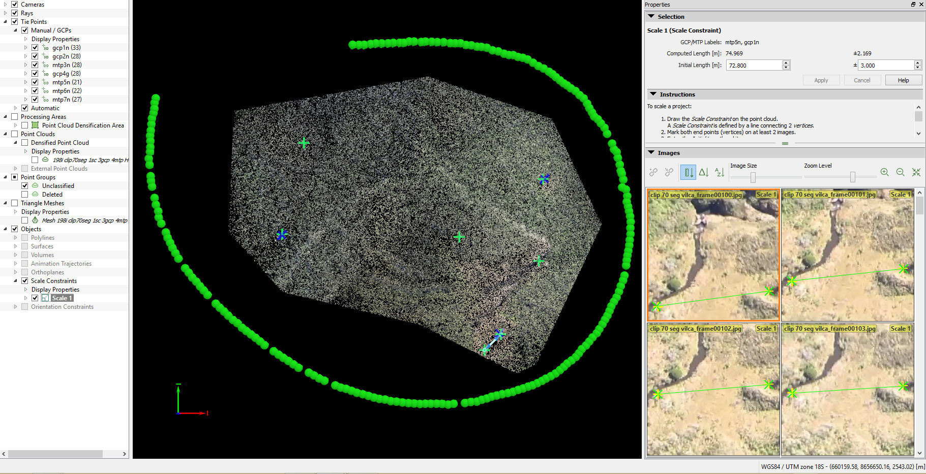
-----IIIc: Georeferencing and Scaling is
performed using Google Earth as reference. This is a painstaking job
which demands much operator experience in order to minimize errors.
These are due to the difficulty in identifying common points between the
Google Earth image and the Point Cloud in part due to the low resolution
of the images and also due to the complexity of the jungle landscape.
Image 10 shows the
initial (sparse) Point Cloud after georeferencing with 3 ground control
points (GCP), 4 manual control points and 1 scale constraint to the
original Point Cloud and limiting the Area Processed to a polygon whose
area is approximately 109 Hectares. The
Quality Report
shows some parameters of this result. As
can be seen, the average error in GCP is around 2.7 meters which permits
us to do sufficiently accurate measurements for the purposes of this
report. A short video clip shows that the KML orthomosaic
fits satisfactorily on the Google Earth map confirming the fact that the georeferencing
is adequate.
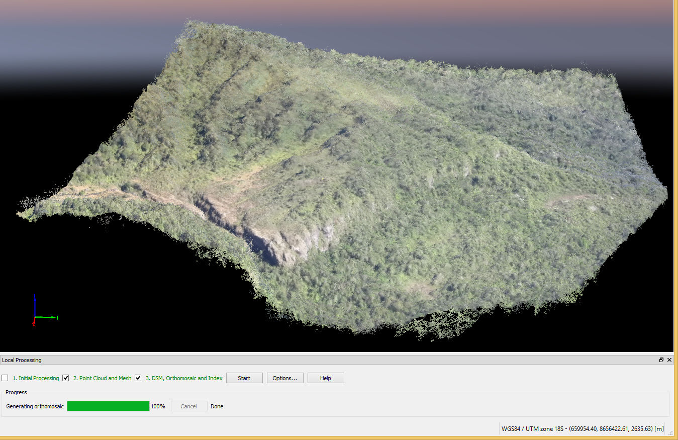
-----IIId: The result of running the
process of densification and texturing ("2.
Point Cloud and Mesh") is shown in
Image 11.
-----IIIe: Preliminary visualization. The following
3D animation gives a general idea
of the topography and the colors. Notice
especially the size of the cliffs in comparison with
the Google Earth version and the difference in colors of the
Secondary
Forest (bright green) compared to the Primary Forest (darker and
grayer green).
-----IIIf: Measuring features
| f1: | Using the 3D Point Cloud view in Pix4Dmapper Pro (see videoF1). These measurements were made as an example from an old reconstruction of the same site with only 52 images (Image 12) taken from the South and East side of the features measured. Further implications of using datasets taken from only one side of the feature of interest are explained in the Conclusions. [The error estimations reported in method 2 of the summarized results in the video use data from the Pix4Dmapper run that are not shown in the video.] | |
| f2: | Using the DSM and Orthomosaic exported by Pix4Dmapper Pro in Global Mapper (see videoF2). Notable features best observed in these map views are the very large almost rectangular (semi-pyramidal) macro structure, and anomalous structures in between two very narrow gullies, one of which receives water from a creek after passing through a small waterfall. | |
-----IIIg: Detailed Visualization (see videoG). In this stage we discuss some of the interesting anomalies that we measured in the previous step, analizing them by texture, color and morphology. -- |
||
IV. Conclusions
-----A.
Though there were problems
of visualization due to the low resolution of the images, dark shadows
and/or lack of sufficient angles for camera triangulation, the quality
of the reconstruction was sufficient for an adequate characterization of
the main anomalies in the area used in the 3D reconstruction. We did 3D and also 2D visualization since both
systems offer peculiar and complementary advantages. Visualization by trained
human eyes makes it possible to detect a series of details in complex
images which computer processing incapable of achieving for the time
being, no matter how sophisticated the algorithms used. Obviously this
capability is tremendously enhanced with the modern computational tools
that are partially described in this document.
-----B.
Though the features
selected for showing the method did not constitute a definite archaeological discovery, we did find anomalies suggesting
probable human intervention, whose age is of course unknowable at this
stage. The exercise demonstrated the power of the
methods used, in spite of the low resolution (only 2 megapixels) of the
video frames used in the 3D reconstruction.
Today consumer grade video cameras have 4K capabilities which is
equivalent to 8 megapixels, that is four times better resolution than
the images used in our example. With this enhanced resolution
and an adequate flight plan, it should be possible to obtain a much
better 3D reconstruction than the one described in the previous section,
and thus arrive at more reliable conclusions regarding the nature of the
features observed.
-----C. The resulting 3D model is vastly superior to that obtainable in Google
Earth (GE), in spite of the fact that the ground sampling distance (GSD
or pixel resolution = 45cm) in the horizontal sense is of the same order of
magnitude as in GE. The basis of the superiority lies in the much better vertical
resolution, where GE fails completely for small objects since
it uses only one satellite image for their visualization, which is
draped over an independent digital elevation model (DEM) obtained from
the Shuttle Radar Topography Mission (SRTM) of the year 2000. Since
November 2014 this DEM for Peru has a GSD of 30 meters for some areas, but in spite of
an important improvement from the previous 90 meter pixel, it is still
impossible to measure vertical distances in GE for
small cliffs or vertical objects. On the other hand, the point cloud
method based on multiple images makes it possible to obtain vertical
resolutions that are of the same order of magnitude as the horizontal
resolutions, thus enabling the viewer to see the sides of objects from
different angles. This is not possible in GE, except possibly
(though distortedly) for very large features whose sides (for example at
angles over 45 degrees) are very large, say 50 meters or more. An
example of this possibility is given by an extraordinary feature we discovered a
couple of years ago at less than 15 kilometers south of the feature that
we used in our example. This
discovery has not been confirmed, since to our present knowledge it has
not been photographed from a close enough range.
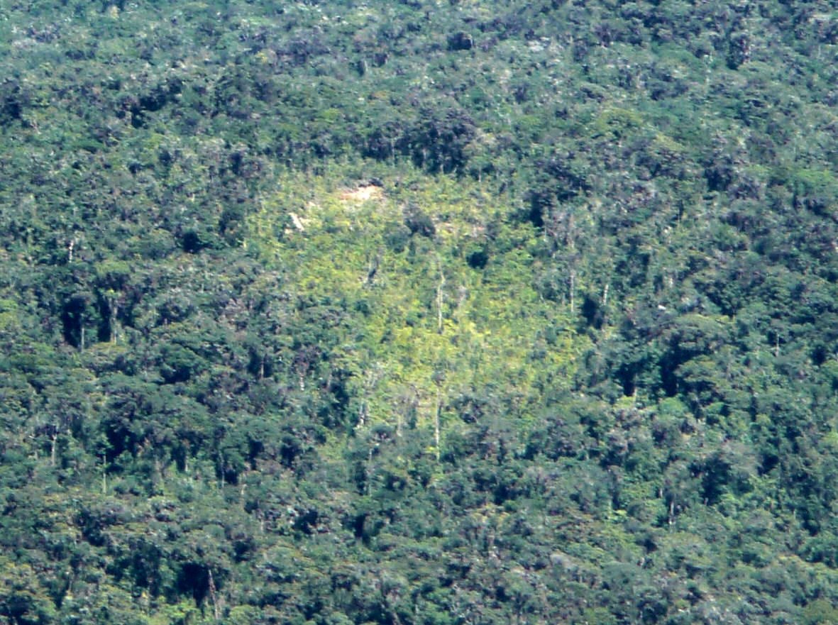
-----D. The analysis in videoG suggests possible human intervention in the small area containing two specific features, a 670 square meter platform and 890+ cubic meter mound right next to it. In addition, across the narrowest part of the southern gully, a bright green vegetation showing Secondary Forest can be seen, including a straight object more than 6 meters long that overhangs the cliff (See Image 13). In the plateaus and deep gorges surrounding this area there is an uncountable number of places with secondary forest, of which the most notable one is the one higher up on the plateau at about 1900 meters to the south east of the reconstructed area (Image 14).
-----E.
As can be seen in section IIIf1, the oblique
images do not have to complete a circle (or ellipse) around the features
to be reconstructed using Pix4Dmapper, in order to obtain results that
are adequate for discovery, even for approximate quantitative
measurements. A further example of this is given in another
reconstruction using 52 frames
from a video taken in 2010 from a helicopter. This may be especially useful in situations where the
features of interest are located in the sides of high mountains, for
example inside of a steep valley, since it would be impossible for the
aircraft to circle the mountain at an appropriate altitude for obtaining
the desired resolution. An
interesting example of this could be the famous Ollantaytambo site in
the "sacred valley of the Incas" of Cuzco. Here the main archaeological
constructions are at altitudes above sea level between 2860 and 3000
meters, while the top of the mountain is over 4000 meters. A reasonable
flight plan here could be a couple of arcs or semicircles the largest of
which would be at around 3200 meters and the smallest higher up at
around 3300 meters, with the necessary precaution of keeping a safe
distance from the cliffs.
-----F.
Manned AirCrafts (MAC) vs Drones (UAV): which are applicable for our objectives?
In the case of the mountainous amazonic region of our study,
clearly MAC is the only option for now. The reason is that the region of archaeological potential - the
plateaus and the higher parts of the Cutivireni River Basin - is far
away from any possible access by land so the only immediate options are overflights
by airplane or helicopter.
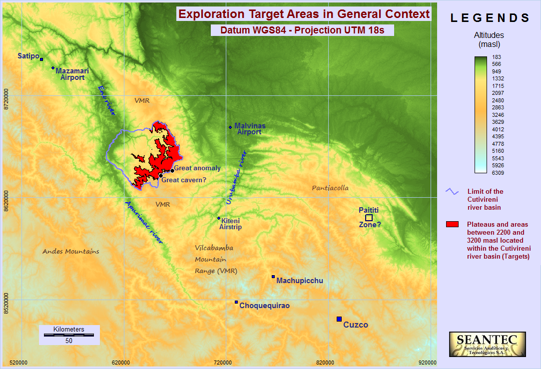
Image
15 illustrates this point. The red highlighted areas shown in this
image, spanning approximately 1000 square kilometers, include a multiplicity of possible
target sites for exploration such as those shown in the first two chapters and in the Appendix of this
study. Access by land will be feasible when areas apt for helicopter landing
(or rappel)
are identified after the first overflights are accomplished with the
corresponding detailed photogrammetric surveying using methods as described above.
-----Once the more interesting archaeological
areas that can support helicopter landing are identified, and the
permissions are granted by the authorities, drones will be the best
option for obtaining the best quality of 3D models, orthomosaics and
topographical models for a detailed characterization of the respective
sites.
-----If access can be
achieved into at least some of the caverns, they can be efficiently
mapped using modern surveying systems such as
Field Map. As modern
photogrammetric systems based on multiple images keep improving,
spectacular 3D models can be obtained of these caverns, perhaps using
infrared cameras with that can "see" in the dark or even spherical (360°) cameras.
--
V. Planning future projects
-----Image 15 shows that there are
only two airports, Mazamari and Malvinas, close enough to the target areas with archaeological potential
mentioned in this study, from which aerial expeditions could be realized advantageously. Mazamari is approximately at 140 Km and Malvinas at 76 Km in a straight line
from the center of the mentioned areas. Using a single motor Cessna airplane would be
most convenient, since the wing of these airplanes is over the fuselage and does not interfere with
the video and image capture. Logistic and economic factors should be analized
and most importantly, the weather should be closely monitored, due to
abundant seasonal tropical storms and even sporadic rainfalls in
the "dry season".
-----Though
the Mazamari airport is around 40 minutes away from the area of the
exploration targets, whose locations are well identified from our previous aerial expeditions, a total of
140 minutes should be sufficient for each overflight from Mazamari (one hour
for circling
a couple of targets) if the weather is OK and the flight plan and image
capture is adequately executed. This airport has the advantage of being at 20 minutes
distance by land from the headquarters of the Otishi National Park, that is the
authority in charge of the protected areas that comprise the targets of
our proposed explorations, one of whose representatives must be a part
of each expedition over the Park. Also, though the Malvinas airport is much closer,
this
airport is dedicated to servicing the administration of the natural gas
installations of Plus Petrol in
Camisea and
Malvinas, so it would be more difficult to
adequately plan the flights from there.
-----The Kiteni airstrip is a third
possibility, but though it is closest to two of the most atractive
features in the southern flank of the Cutivireni plateaus, reaching
Kiteni entails the greatest cost. The main advantage of this location is
that modern
helicopters operate there, used in the monitoring and maintenance of the
gas pipeline that goes from Malvinas to
Pisco (a second
pipeline transports most of the gas to Lima). Using a helicopter instead
of an airplane offers definite advantages for image capturing, but is
much more expensive.
-----A critical aspect to be planned is the
required close
coordination between the Company or Association that designs the
expeditions and the pilots of the airplanes or helicopters in which they will be
carried out. The flight over the predefined targets must be carried out as
closely as
possible to the flight plans, otherwise the quality of 3D reconstruction
will be hampered. The flight plans must be discussed at length with the pilots in
order to take into account technical constraints of the flights.
--
VI. Epilogue
for the study of the Cutivireni plateaus in the mountainous jungle in
Perú
-----
The main concern which motivated this study is
the proliferation of narcotraffic and terrorism in the Ene river, part
of the
VRAEM system of valleys, at around 60 kilometers from the areas
described above. This unfortunate situation is probably the main reason
why the eco-touristic potential of the region has not been developed
until now, this being its only sustainable alternative for development
given its extraordinary natural landscapes and archaeological potential.
If we could organize one flight with a light airplane and make a couple
of important discoveries with the methods described in the above report,
we would attract international attention and financing for further
expeditions and archaeological studies.
-----Once the archaeological
potential has been confirmed, and the approval of the neighboring native
Ashaninka and Machiguenga communities of the area has been secured, then
interdisciplinary studies of eco-touristic projects can be carried out
for fostering the sustainable development of the region, with adequate
environmental and social management. This could eventually help to turn
the tide against the widespread corruption that is ruining the moral
fibre of the Nation. We need help from people that are sufficiently
intelligent and conscious of the need to protect the environment and
thus the native people, but this cannot be done without well planned
projects that can be adequately financed. This is a long term view, but
my concern is that the more we delay the more damage is done to the
environment, and we would lose another battle against Corruption, with
all the dire consequences that this entails.
VII. Explorations using Drones in the Southern Coastal areas of
Peru, mainly including the Ica Desert
-----Notwithstanding the
great potential importance of the area of the Cutivireni river basin covered in
the previous sections of the present report, there is another region in
Peru that has perhaps a greater potential for tourism. Its main
features are centered around a very famous and
mysterious archaeological wonder, known worldwide as the Nasca and Palpa lines
and geoglyphs located in the south-eastern part of the Ica Region in Peru
(see
political map). A great advantage of the Nasca (*) and Palpa zone is that it
is readily accessible due to its basic existing infrastructure (see
general tourism Map in a preliminary draft from Google Earth). (*)
Note that in English speaking countries Nasca is still referred to as
Nazca, but this has changed in Perú, and also in the
UNESCO
reference.
-----In this section we will
show a few results obtained with images and videos taken with
quadricopter-type drones, an effective
method for developing photogrammetric 3D models that are very useful for
exploration purposes and detailed analyses.
-----As
a general background, the great desert in the Ica Region of Peru,
covering an area of more than 10,000 square kilometers,
contains some of the most important archaeological and paleontological
zones of Peru, and even of the world. Searching with Google under
"Touristic potential of the Ica Region in Peru" we find 585,000 results,
of which the following links will start giving
us an idea of the yet untapped but extraordinary potential of this
region:
-----(a)
Peru: Nazca's to-be-unveiled tourism potential | Noticias | Agencia ...
(b) Ocucaje:
Buried in Peru's Desert, Fossils Draw Smugglers.
(c)
Paracas is an already developed tourist center that is at around 210
Km by highway from the city of Nasca.
Model VII-1
The area of this
model is approximately 11 hectares centered around the following
coordinates:
14°10'29.32"S; 75°50'58.15"W. This location is at 56 km
southeast of the Paracas tourist center and 90 km northwest of the Nasca
lines zone, as the crow flies. The access is from the city of Ica in two
sections: the first is along a paved highway westward for 14.8 km and
the second from location (14°6'31.22"S, 75°51'0.56"O) through a dirt
road for approximately 8.4 km.
For
this model we show two images.
Image vii-1a is divided into two parts. Part A is a view from Google
Earth of the area, and part B is an oblique 3D view from the Pix4Dmapper
software showing the relative positions of the photos taken with the
drone using the Drone Deploy App for automatic flight and image
retrieval.
The following image shows a
surprising finding that is an example of the potential of modern
photogrammetric technologies for new discoveries in geological and
archaeological exploration.
Image vii-1b
shows the Orthomosaic and the Digital Surface Model (DSM) obtained with
Pix4Dmapper Pro and exported to Global Mapper. The DSM shows a large nearly circular
depression whose diameter is estimated to be over 500m since the area
covered by the model is clearly not large enough. If this depression was
not caused by a large meteorite, it could be an indication of an artificial
underground site which should merit further investigations,
perhaps including careful excavations or other modern underground
detection systems. The point here is that the great Ica desert holds an
immeasurable number of important buried archaeological and paleontological sites,
and fundamentally requires a thorough revision of the geology
of the region, including accurate dating of the various strata with double
checks using modern equipment and techniques.
Model(s) VII-2
(this case study is part of a critical regional problem which needs to
be studied in depth)
The
following models of one of the flat hills in the Palpa Province
of the Ica Region were obtained using images taken from a DJI Mavic Pro
drone on July 30, 2017. The basic model, using 18 vertical (nadir) 12
megapixel images, covers 34 hectares which is enough to include the flat
area of around 7.5 hectares and surrounding slopes, and has a GSD
(ground sample distance) of 8.1 cm/pixel. The larger model uses
aditionally 120 frames (8 megapixel) from two 4k videos, covers 107
hectares and its GDS=11.9 cm/pixel. The smaller model is "cleaner" (less
noise) and is the one used for the analyses done in the
linked essay, which is an ongoing attempt to understand the real
significance of this hill (or mountain if you please) as a model for
explaining many of the mysteries of the Nasca and Palpa geoglyphs.
Next we show here the still views of both models together with the
positions of the images used, and present the respective video
animations. When possible we plan go back to the site and shoot closer
images of the more interesting areas in order to construct 3d models of
much greater detail, perhaps under 3cm/pixel. This was not done in our
previous visit since our initial objective was to get a complete view of
the hill with a reasonable amount of photos.
Still images:
SiBasic Model and
SiExpanded Model.
Video
animations:
VaBasic Model and
VaExpanded Model.
Models VII-3: Photogrammetry in Nazca.
In February and March 2018 our friends of
TheDrone Peru have made several drone flights in
the zone of
the world famous geoglyphs. One objective was to examine in detail the
sensational
discovery, published in Dec. 10, 2017 by José Luis Camacho of the
"Mundo Desconocido" YouTube Channel, of 18 "circles" that are
mysteriously aligned for 18 kilometers and extrapolate to what seems an
ancient cemetery. We have modeled the last two (17 and 18) that are
sufficiently close to the highway (within the range of modern DJI
drones), using rigorous photogrammetric methods. The result can be seen in two images obtained by processing
pre-planned sets of nadir images with Pix4Dmapper:
Circle_17 and
Circle_18.
Both show almost exactly the same diameter: 8.33 meters for the outer
ring. We have published a
YouTube video
(9:08 min, in Spanish), on these circles
showing other contextual aspects not previously covered, but this is an
unfinished job whose purpose is to highlight the need to protect the
area from further depredation, and promote sustainable development of
the Region. A
second video on these circles (6:40 minutes, in English) shows new
measurements and a discovery of surprising internal properties of the
circles made by a Carlos Escobar, a geologist who is collaborating with
our investigations.
A second
project that we have published based on a flight with a drone, is a photogrammetric
analysis of a famous geoglyph of a Tree located right next to the
PanAmerican highway. In this
short video
(4:44 minutes) we show the steps done to obtain various measurements of
the geoglyphs, the last two of which cannot be done with the present
satellite images due to their insufficient resolution. A similar job can be done for all the rest of the
lines and geoglyphs of Nasca and Palpa, but instead of using a drone, we
recommend taking the images from an
airplane for a much faster and non-invasive capturing of the hundreds of thousands
of images required. This is a job that requires much planning and coordination
with the authorities, but which we consider essential for the
preservation and restoration of the damaged geoglyphs. The
extraordinary power and low cost of the modern surveying technologies
gives peruvians a good opportunity to do this job in a fairly short time.
Speed is essential in this work given the critical situation, not only
of Nazca but of the country as a whole.
Models VII-4: Videos of other 3D models from southern coastal areas in Perú, to be analized in future updates.
Ica dunes,
Huaca El Salitre,
La Centinela ruins complete,
La Centinela ruins partial
---------------------------------------------------------------------------------------------------------------------------------------------
APPENDIX.
Examples of the
use
of stereo anaglyph images for analyzing some features of interest in the
Cutivireni plateaus. (Note: the use of Red-Cyan glasses
![]() is recommended, instead of Red-Blue.)
is recommended, instead of Red-Blue.)
-----A1.
Possible hidden structures of Images 1 and 2 (Image
A1).
-----A2. Tower of
Image 4: The two photographs used for this anaglyph image were taken too
close from each other so the depth of the tower and especially that of the broken piece in the
front are not optimally represented in this anaglyph (Image
A2).
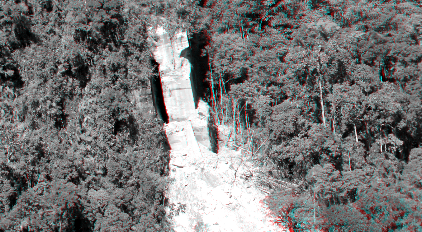
-----A3. Cavern of Image 5 (Image A3).
-----A4.
Great anomaly (Image A4) at less than 12 km distance from the features
reconstructed in Chapter III of this report. The anaglyph was made from
two vertical (nadir) photographs taken by the National Air Photograph
Service of Peru. There is a vertical exaggeration in the view since the
pair of photos for the reconstruction were taken far apart from each
other.
--
BIBLIOGRAPHY
P. A. Rizo-Patrón:
The Ene River Basin in Perú - its geography and potential
for tourism,
in "The nature and culture of Latin
America : review of Polish studies", Zbigniew Mirek, Adam Flakus,
Andrzej Krzanowski, Andrzej Paulo & Janusz Wojtusiak (Editors), W.
Szafer Institute of Botany, Polish Academy of Sciences, Kraków, 2010,
pp. 105-134.
For a PDF copy of the published article Click here
(includes hardcover image, book and copyright information, Foreword by
the Editor, Introduction in Spanish, Contents of the book, and the
complete article - 15.9 megabytes). For printing or exporting to other
users please contact the author.